Marooned Mobile App
Mobile | UX | Process | Personas | Prototype
The Challenge
Texas A&M University in College Station is home to more than 50,000 students and gets thousands of visitors every year. With over 5,200 acres to explore and new construction projects putting up new buildings every year, navigating around campus can be a challenging. With this information in mind, the design challenge is to make navigating around the Texas A&M campus easier for both visitors and locals.
Contribution
Gathering User Needs, Observation, Interview, Questionnaires, Task Analysis, Personas, Scenarios, Task Diagrams, Affinity Diagramming, UX layout, Mockups, Look & Feel, and Asset Creation.
User Needs
Two key user needs determined by our studies were parking and navigating to campus buildings and events. There was no discernable difference between the needs of locals and visitors.
Personas & Scenarios
Every day, many people come to the Texas A&M campus. Many students, faculty members, and visitors - both familiar with campus and completely new - struggle with campus navigation on a daily basis. The available resources for on campus navigation are poorly designed, difficult to find, and can be easily misinterpreted, leading to very frustrating moments for everyone. In this analysis of collected user data we identify four common Personas and Scenarios associated with this problem. We have created two Task Diagrams based off of a user study in order to identify the major problems faced by people trying to find their way around the TAMU campus so that we can eventually realize a solution.
Locals & Visitors
|
John
Tech Savvy Visitor: Business Professional Smart Device: Yes Age: 29 About: John takes pride in being up to date with all the current technology and often come to TAMU campus to visit his girlfriend, who is a student at Texas A&M University. Important: Being on time. Frustration: Not knowing where buildings are or where to park. John pays to park in Visitor parking on campus and frequently receives parking tickets from the TAMU police. |
|
Kathy
Tech Savvy Local Student Smart Device: Yes Age: 20 About: Kathy is a busy student who has classes in different buildings across TAMU campus. She enjoys meeting up with her friends in the evenings to study and active on social media websites. Important: Participating in Greek Life events on TAMU campus. Frustration: Kathy has trouble locating parking on campus in the evenings. She often has to park far away from where she is trying to go. |
|
Daniel
Non-Tech Savvy Visitor High School Coach Smart Device: No Age: 65 About: Daniel enjoys watching sporting events and is a proud Texas A&M Alumni. Important: Attending TAMU sporting and Alumni events. Frustration: Daniel is glad the university is growing; however, he is frequently disoriented by the new buildings and construction on campus. |
|
Andre
Non-Tech Savvy Local Professor Smart Device: Yes Age: 41 About: André greatly enjoys his research in Political Science. He especially likes to be informed about current Local and Federal Government interactions. A back injury André received from a car wreck when he was younger makes standing for long periods of time and walking long distances painful. Important: Attending speeches from important government officials on-campus, such as George Bush Library or Rudder Auditorium. Frustration: André is constantly frustrated with the timeliness of the Transit system and construction on campus making cross-campus navigation difficult. |
Savvy Student Parking Woes
It’s 4:45 pm and class is about to let out for Kathy. Her social media websites remind her that she must meet with her sorority at 5:00 pm to plan their annual charity event. She does not remember where they were meeting and quickly goes online and asks on her social media page. A friend of her responds and tells her they are meeting at the Medical Sciences Library, which is in West Campus. Kathy has no idea where this building is since she only has class on the main side of campus. She uses the TAMU Campus Map and quickly locates the building on her laptop before class is over. As she walks out to her car she maps out the route she will take on her phone using the TAMU Campus Map.
She arrives at the Medical Science building in time for the meeting and is especially happy about being able to park right outside the building since it’s night time. Later on that night as Kathy leaves her meeting she received a ticket for parking in a paid parking spot. She quickly goes online and checks the TAMU Campus Map; unfortunately it does not have any parking information on it. So she searches online again this time for the TAMU Parking Map and finally finds out that the lot she parked in is Visitor Parking only.
She arrives at the Medical Science building in time for the meeting and is especially happy about being able to park right outside the building since it’s night time. Later on that night as Kathy leaves her meeting she received a ticket for parking in a paid parking spot. She quickly goes online and checks the TAMU Campus Map; unfortunately it does not have any parking information on it. So she searches online again this time for the TAMU Parking Map and finally finds out that the lot she parked in is Visitor Parking only.
Design & Wireframe
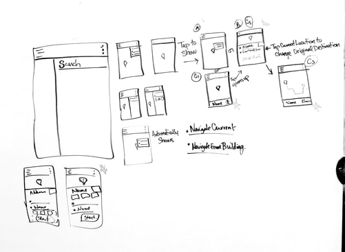
A simple to learn and intuitive design that ultimately eradicates unnecessary and/or partially helpful campus navigation resources to centralize information to one source.
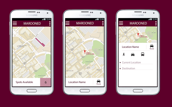
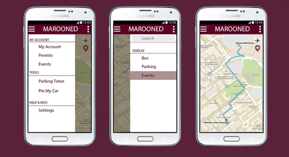
The centralized system of information encompasses all of what our users want and need. In centralizing the different information offered by the applications currently used, the user can go to one place, and access all the features needed. The system would includes features such as Google Maps navigation system along with the pin feature, TAMU Campus Map for it's search Building functionality, TAMU Parking Map for it's parking information, and ParkMe for it's mark my car feature. Many of these features have been addressed in other design solutions. This system incorporates all of these features into one central platform, where all the data can be accessed easily.
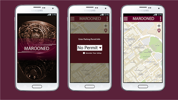
This system will also feature Real-Time Parking Lot updates using the information stored by the TAMU Department of Transportation. The Real-Time Parking would supply users with up to date information about what parking areas have spaces available to park in. This would also provide users with what parking spaces are currently available to them 24/7, year round based on their own Parking Permit information.
Prototype
The horizontal prototype is intended to establish the breadth of functionality the user has on the web page/application. While no functionality, the prototypes purpose is to consolidate as much information as possible. We want to showcase how our prototype contains all of the necessary information and is still easy and simple to use. Further iterations of prototype will feature fully-functional aspects of all of the design features.
Incremental prototyping is suggested so that prioritized functions such as GPS, navigation, map, and search bar are delivered. Real-Time Parking will then be integrated, followed by the live tracking of the TAMU Bus System, and finally locations of TAMU Campus Events. Through this iterative process we are able to accurately implement important features and perform more user studies along the way to ensure that we are meeting all of our user's needs.
Incremental prototyping is suggested so that prioritized functions such as GPS, navigation, map, and search bar are delivered. Real-Time Parking will then be integrated, followed by the live tracking of the TAMU Bus System, and finally locations of TAMU Campus Events. Through this iterative process we are able to accurately implement important features and perform more user studies along the way to ensure that we are meeting all of our user's needs.
Evaluations
Overall users had a good experience, but there were still areas that were unclear. User's also suggested to add certain features to the design:
- The ability to pay for parking through the app.
- Graphic icons for the drop down menus.
- A more noticeable search box.
